Back to Portfolio

Regional planning and policy framework

Proposal: The Capital Region Eastern Greenway

An integrated mobility, conservation, and development strategy for the eastern edge of Greater Lansing.

Status

Independent concept paper prepared as a sample of Cognisint's public-works and institutional strategy practice.

Conceptual illustrations are planning aids requiring engineering, surveying, cost, and feasibility review.

Facility

Limited-access expressway*

Roadway

Two through lanes each way

Access

No parcel driveways or frontage

Purpose

Mobility with binding anti-sprawl controls

* Expressway And Freeway. An expressway limits direct property access and may include selected at-grade intersections. A freeway uses full access control and grade separation. The terms are often used interchangeably in Michigan and elsewhere in the United States. The Greenway combines limited parcel access with selected at-grade public-road intersections; only its I-69 and I-96 termini are conceived as grade-separated interchanges.
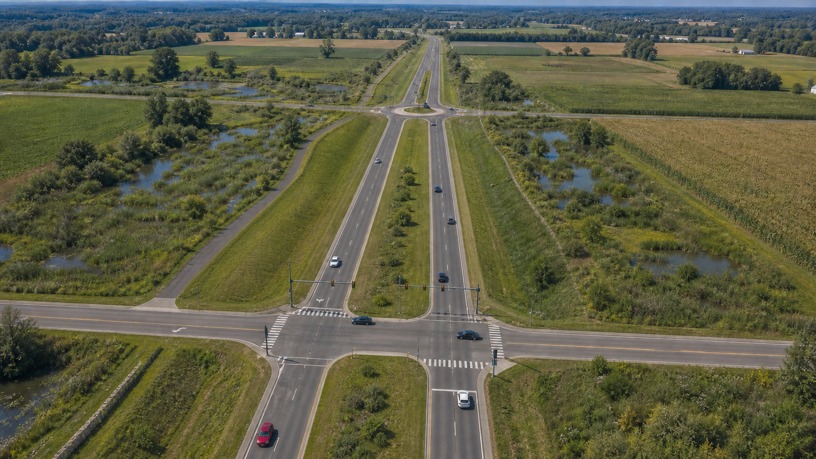
Photorealistic aerial concept of the Capital Region Eastern Greenway passing through protected farmland and wetlands, with a signalized intersection and a roundabout
The Greenway combines a divided, limited-access roadway with a permanent conservation landscape. Selected roads meet it at carefully designed at-grade intersections; the absence of driveways and frontage access preserves regional movement and prevents ribbon development.

Regional Context

The Missing Eastern Connection

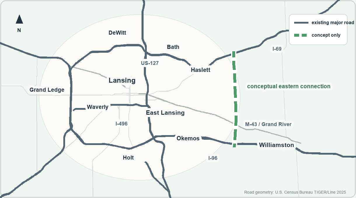
I-69 arcs across the north of Greater Lansing, I-96 across the south, and US-127 and I-496 carry much of the central north-south and east-west movement. The regional system has no comparable eastern leg between I-69 and I-96.

The Greenway tests whether that missing connection can be supplied inside a permanent conservation corridor while avoiding the land-consumption pattern of a conventional beltway.

Simplified regional road map showing Greater Lansing's existing major roads and a dashed conceptual eastern connection
Simplified regional context. Existing major roads wrap around Lansing and East Lansing on the north, west, and south; the dashed green line shows the missing eastern connection as a planning concept. Existing road geometry is from U.S. Census Bureau TIGER/Line 2025.

Consequences The Design Must Address

Does Regional Mobility Require Harsh Tradeoffs?

High-volume roads were built to connect places, shorten trips, carry freight, and open access to jobs. They did those things. They also displaced residents, divided neighborhoods, made automobile travel the easiest or only practical choice in many places, and extended development into land that required ever more roads, utilities, and public services.

The consequences differ with context. When high-volume roads were built through established urban neighborhoods, acquisition and the roadway itself displaced people and divided the communities that remained. When the same road-building model extended into suburban and rural land, it encouraged automobile-dependent development and spread infrastructure, environmental, and service costs across a larger area.

When High Volume Roads Cut Through Developed Communities

  • Acquisition can remove homes, businesses, institutions, and historic places. Compensation cannot re-create the resulting customer bases, social networks, or neighborhood economy.
  • The roadway can sever vehicle and pedestrian connections, turn local streets into dead ends, and isolate parts of a neighborhood. The Olds Freeway/I-496 did this in Lansing.
  • Urban freeway and urban-renewal programs often cut through racial and ethnic minority, low-income, immigrant, and working-class neighborhoods where land was cheaper or political resistance was weaker.

When High Volume Roads Extend Through Suburban And Rural Areas

  • Fast roads, stroads, and dispersed development can make walking and bicycling indirect, encourage automobile trips, and make fixed-route transit difficult to support.
  • Roads and the development they enable can consume farmland and green space, fragment habitat, alter water systems, and increase wildlife-vehicle collision risks.
  • Dispersed growth extends roads, utilities, emergency response, and other public services across a larger area, creating long-term maintenance and operating obligations.

Effects In Either Setting

  • New capacity can attract diverted, longer, shifted, or entirely new trips; evidence and modeling must establish any congestion relief.
  • More driving creates more crash exposure, higher speeds increase severity, and construction and maintenance consume substantial land, materials, and energy.

The Greenway's Response

  • Control access through strict frontage limits and selected crossings, with development concentrated at compact nodes.
  • Protect land while providing a separated trail, transit reservation, and integrated water and wildlife systems.
  • Compare the proposal with a genuine no-build alternative and account for its full lifecycle costs.

The regional choice

Build Infrastructure Before Fragmentation Makes It Cost-Prohibitive

Greater Lansing, including many areas within a short distance of suburbanized or even fully urbanized areas, still possesses a coherent eastern landscape of farms, wetlands, woodlots, and open land. Growth from Okemos and Haslett toward Williamston and Bath is steadily consuming that coherence. Once the land is divided by scattered subdivisions, driveways, and utility extensions, both conservation and meaningful corridor planning become far more expensive.

The Greenway responds before that pattern becomes irreversible. It combines a north–south regional mobility route with protected open space, natural water management, habitat continuity, recreation, nonmotorized transportation, and a framework for concentrating new development at planned nodes.

The Greenway offers a potential response to transportation, green space, conservation, and growth management needs by combining the regional connectivity of a beltway, the landscape integration of a parkway, and the land protection of a greenbelt while accounting for the problems associated with each. It directs growth toward places where infrastructure can support it while preserving the landscape that gives the region its identity and resilience.

Road Design

The Greenway's Design

A four-lane, limited-access roadway with two through lanes in each direction, a wide future transit and managed-flex reserve, selected at-grade junctions, and grade-separated I-69 and I-96 termini.

  • Only the I-69 and I-96 termini are conceived as grade-separated interchanges.
  • Major intermediate roads remain selectively permeable through signals, roundabouts, Michigan Lefts, RCUTs, or other forms selected for the specific location.
  • The Red Cedar River bridge and likely railroad flyovers are separate crossings.

Corridor geography

A New Eastern Edge For The Capital Region

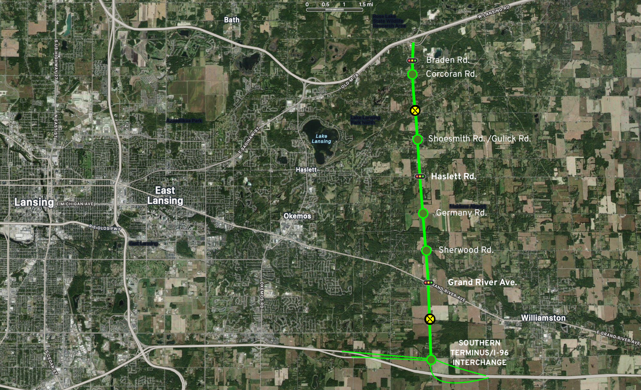
The conceptual route follows a north-south alignment along Woodbury, Shoesmith, and Burkley roads and property lines from I-69 to I-96, east of Haslett and Okemos and west of Williamston. Much of the southern half crosses farmland where no road exists today.

Conceptual route map for the Capital Region Eastern Greenway between I-69 and I-96
Conceptual route map. Exact alignment, intersection control, environmental impacts, right-of-way, and costs require formal study. The concept assumes no direct frontage access and permanent conservation controls within the corridor.

The Corridor As A Public Landscape

How The Corridor Fits Together

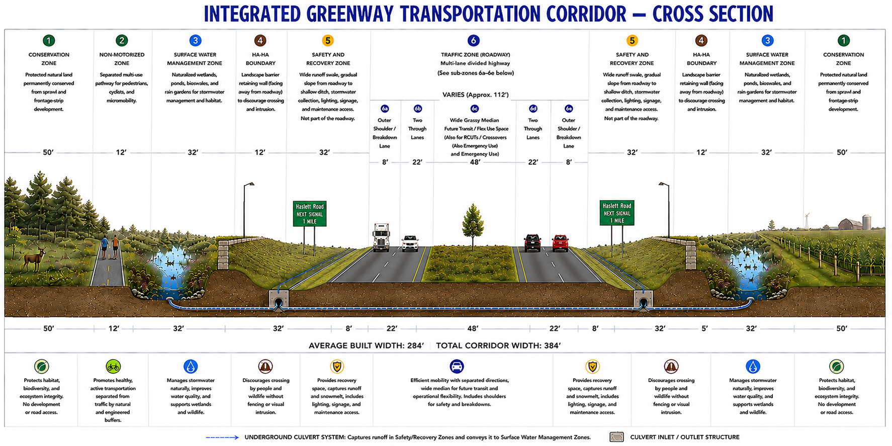
The Greenway is organized as a sequence of functional zones. The road functions as one integrated subsystem within a wider environmental and civic corridor whose optional features can be adapted by location.

Conceptual cross section of the Capital Region Eastern Greenway showing conservation, trail, water management, ha-ha, safety, roadway, and median zones
Conceptual cross section. The sequence of roadway, recovery, water, trail, landscape, and conservation areas illustrates how the corridor's functions fit together. Dimensions remain subject to engineering and environmental study.

Conservation And Access Control

Public land, conservation easements, farmland-preservation agreements, development-rights acquisition, and limited-access rights establish a durable green edge without requiring public ownership of every adjoining parcel.

Water And Habitat Infrastructure

Naturalized ponds, wetlands, bioswales, rain gardens, culverts, and wildlife passages manage runoff and snowmelt while maintaining ecological continuity.

Movement At Several Scales

Regional traffic, transit, walking, cycling, recreation, and local crossings occupy distinct but connected spaces. The design preserves safety and legibility without turning the corridor into a wall.

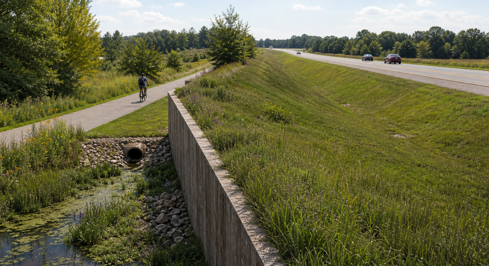
Conceptual landscape-facing Ha-Ha edge between a nonmotorized trail and roadway safety zone
The landscape-facing “Ha-Ha” is one possible boundary treatment within the larger water, safety, trail, and conservation system.

Design Detail

A Landscape-facing “Ha-Ha”

A “Ha-Ha”—a short, abrupt retaining edge paired with a ditch or change in grade—is one possible boundary tool. Here, its visible face would address the landscape and trail side while the roadway side rises gradually. It could discourage entry and help guide people or animals toward designed crossings while preserving open views.

History As A Design Constraint

Black Lansing And MSU: Same Region, Unequal Result

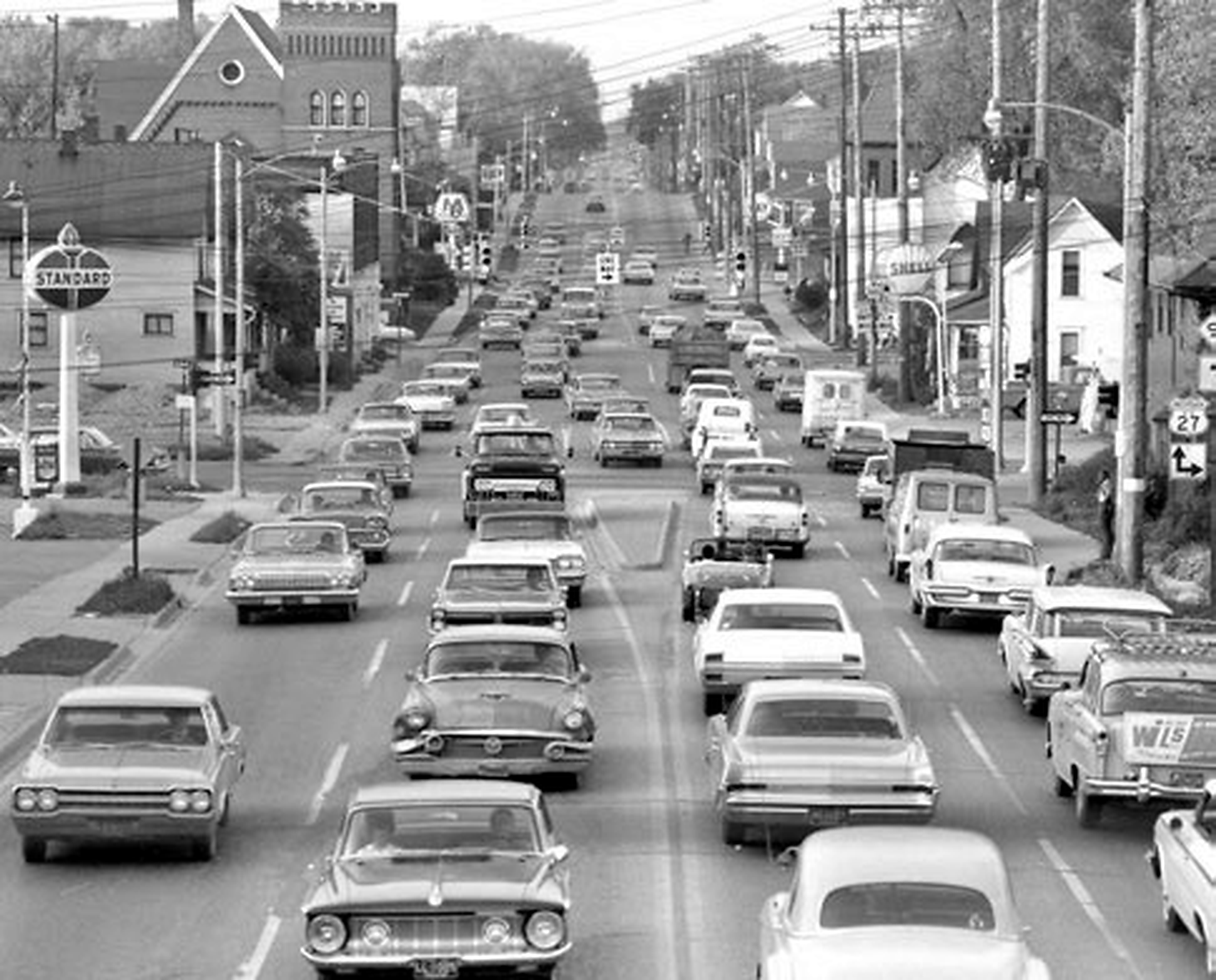
Historic view north on Logan Street across Main Street and St. Joseph Highway before I-496
Logan Street looking north across Main Street and St. Joseph Highway before I-496. Undated photograph published in City Pulse, December 5, 2018, p. 12; the photographer and rights holder are unidentified.

In the 1960s, I-496, also known as the Ransom E. Olds Freeway, cut through Main Street and the heart of Black Lansing, removing homes, businesses, community institutions, and historic landmarks, including—ironically—the Ransom E. Olds mansion. Its costs were borne by a community with little power to alter the state's preferred alignment.

The proposed cross-campus freeway—the eastern half of the same crosstown route, intended to connect where I-496 meets US-127—met a different fate. John A. Hannah, MSU's president from 1941 to 1969, oversaw the university's rise to national prominence. In 1971, after sustained student, faculty, neighborhood, and municipal opposition, the MSU Board of Trustees rejected the route and East Lansing withdrew support.

MSU possessed leverage unavailable to Black Lansing. The university built during Hannah's presidency controlled a consolidated campus, had a powerful governing board, substantial wealth and political standing, and benefited from the racial and institutional privilege accorded a major public university. Black residents and merchants along Main Street—already constrained by discriminatory housing, lending, and real-estate systems—lacked a comparable institution able to force reconsideration.

Transportation choices distribute power as well as movement. The Greenway begins with those consequences in view.

Facility Type

Rethinking Michigan's Road Strategy

Michigan's historic preference for either full freeway construction or no meaningful improvement has obscured useful middle forms: expressways, super-twos, access-managed bypasses, and selective grade separation. The Greenway is one example of innovative thinking outside a freeway-or-nothing binary.

Future Governance

A Design Adaptable To The Needs Of The Community Now And In The Future

The Greenway is designed to meet present needs while preserving room for future transit, managed operations, revised intersection treatments, and other mobility technologies when evidence and funding support them. Future communities retain authority to modify the corridor to address new needs or choices. Later freeway conversion would require new right-of-way, overpasses, ramps, environmental review, funding, and public authorization. The present design directs current investment toward current needs while leaving that future decision open.

Read The Complete Proposal

What The White Paper Covers

The revised white paper develops the historical case, corridor concept, access model, known transportation and land-use risks, conservation strategy, cross section, stakeholder framework, and questions requiring formal study.